
Planning Consultants Anglesey: Successful Livestock Shed Application.
- Admin
- Aug 3, 2025
- 5 min read

Updated: 7 days ago
Introduction
En-Plan were emploed by the applicants to deliver a partially retrospective planning application for the excavation of land and erection of new agricultral building adjacent to scheduled ancient monument on the Island of Anglesey in north Wales. The process was a trciky one as the applicant had already completed the excavation process and as in depserate need of new agricultrual sheds to act as winter accommodation for his sheep and to house his agricultural equipment, and we needed to obtainn apporval to avoid planning enforcement.
Summary of Proposals
The application at Mynydd Celyn Mawr is part retrospective for the regularisation of
engineering works associated with the creation of a hardstanding together with the erection of two sheds for agricultural and equine purposes, and was submitted to Anglesey County Council.
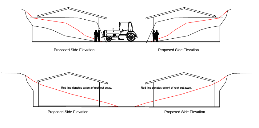
The design concept is based around the use of existing topography and lowering of the site level to provide screening for the proposed development that will ensure the development is screened from any sensitive vistas. Development site from atop natural rise (5m above site) as shown by the below architetcural plans produced in house by our architectural services team.


The Planning Assessment
Application FPL/2024/50 - Full application for the retention of excavation works and construction of two sheds for livestock and stables on land at Mynydd Celyn Mawr, Caergybi, Holyhead.
In 2020, planning permission was granted under application FPL/2020/62 for the part
retrospective regularisation of engineering works associated with the creation of a hardstanding together with the erection of a shed for agricultural and equine purposes. The two new proposed sheds for livestock and stables will be located next to this previously consented agricultural building.
It is unclear whether Cadw were consulted on the 2020 development, however, as the proposed new sheds are within 500m of a Scheduled Monument (AN033 Plas Meilw Hut Circles), a proportionate Heritage Statement was therefore submitted to assess the impact of the scheme. The primary aim of the HIA is to explore the potential impacts of the proposals upon the heritage significances of the listed building, in line with the requirements of planning law and policy relating to the conservation of the historic built environment.
En-Plan worked in partnership with Adfer Conservation to asses the impact of the proposal on the aforemenmtioned Stone Circles with approach taken in the preparation of this statement adherering to the principle of managing change intelligently, which lies at the heart of national planning policy for conservation of the historic built environment. The Heritage Impact Assessment assesses heritage significance and guides proposals for change in a manner that conserves significance and avoids harm. The approach adheres to the principle of managing change intelligently, which lies at the heart of national planning policy for conservation of the historic built environment.
As mentioned in the opening paragraphs of this Heritage Statement consent has previously been given to an area of hardstanding together with the erection of a shed (FPL/2020/62). This application is located on the same piece of excavated ground and is located within 50m of the Plas Meilw Hut Circles, which is a Scheduled Monument (AN033). Whilst the two remaining hut circles is located approximately 200m from the site, it isimportant to remember that the extent of the scheduled monument extends to within 50m of the southernmost boundary of the excavated/engineered area
The hut circles are set on slightly elevated ground, providing a vantage point over the
surrounding area. The landscape around the site is open, with views across the
undulating countryside of Holy Island and towards the coast. The area around the hut circles is largely covered with grass and low shrubs. The wild, exposed nature of the site is typical of Anglesey’s coastal terrain, with hardy vegetation able to withstand the maritime climate.
En-Plan have created a useful photographic survey and digital mapping to demonstrate that the development site cannot be experienced from the scheduled monument, nor from the wider environment.
Section 28 of Cadw’s ‘Conservation Principles for the sustainable management of the Historic Environment in Wales’ sets out the instances where new work and alterations will be acceptable. New work or alteration to an historic asset will normally only be acceptable if the need for the work is fully justified. In this instance the proposed outbuildings are required by the applicant for the continued and viable use of Mynydd Celyn Mawr, which is a historic farmstead (appears on 1841 Tithe Map).
Sufficient information was submitted to comprehensively understand the impacts of the proposal on the significance of the asset; The research undertaken shows the significance of the asset. The proposals do not impact the scheduled monument in any way. There is sufficient physical distance not to impact the scheduled monument, and no intervisibility between them and the wider landscape to impact the setting. There is no impact on non-visual elements of the setting and character of the historic asset, such as sense of remoteness, evocation of the historical past, sense of place, cultural identity or spiritual
responses.
Another part of the application process was the production of a Green Infrastructure Statement which is now a standard part of the planning application process. The requirement for Green Infrastructure Statements in Wales stems from national planning policy and environmental duties:
PPW is the principal national planning policy document in Wales, setting out how planning decisions should be made.
Paragraph 6.2.12 of PPW states:“A green infrastructure statement should be submitted with all planning applications… describing how green infrastructure has been incorporated…” and that it should be proportionate to the development proposed.
This policy now applies to most planning applications as a requirement for determination.
The Environment (Wales) Act 2016 places a statutory duty on public bodies (including planning authorities) to maintain and enhance biodiversity and promote ecosystem resilience when exercising their functions.
The GI Statement assists developers and decision-makers to demonstrate compliance with this duty in the planning process by showing how biodiversity and green infrastructure are accounted for.
While Planning Policy Wales provides the planning policy requirement, the Environment (Wales) Act 2016 gives a legal environmental duty that underpins why such biodiversity and green infrastructure considerations must be addressed.
Mitigation was therefore proposed as part of this application in line with recommnedations from the Council Ecologist. The northern and southern boundary will have carefully selected gorse planting to help reduce the jagged appearance of the excavation works. It was important to respect the existing vegetation and plant variety, and not introduce any alien features. Some mitigation measures could have a negative impact within the setting of the historic asset. For example, a screen of trees could be an alien form in an otherwise treeless landscape. No such measures have been proposed at Mynydd Celyn Mawr. No artificial lighting is proposed as part of the development. Natural Resources Wales had no obections to the scheme and aforementioned mitigation.


The proposed development site is located on an existing hardstanding which was granted consent as recently as 2020. There were no objections to the existing hardstanding. The proposed new buildings are low key, agricultural buildings which will have no adverse impact on the surrounding area. Their height and materiality have both been carefully considered to be unassuming as possible, in line with best rural planning guidance. The long-term consequences of the proposals can, from experience, be demonstrated to be benign, largely reversible or be designed not to prejudice alternative solutions in the future.

The Planning Department agreed that the proposed barns are well considered, reasonable and sensitive to the historic assets. The Council concured with us that the works will not result in a direct adverse impact on the scheduled monument, or on its setting. Another great win for our Planning Consultancy which demonstartes how adept we are at shaping the agrarian landscape.


Comments